Optimised Motorway Design and Operation as a Contribution to Vision Zero
Road design from a safety perspective has traditionally focused on appropriate horizontal and vertical alignment, consistent with the design speed, as well as ensuring good pavement conditions for high friction between tyres and pavement.
Road design from a safety perspective has traditionally focused on appropriate horizontal and vertical alignment, consistent with the design speed, as well as ensuring good pavement conditions for high friction between tyres and pavement. This is aimed at avoiding run-off the road crashes and ensuring that sufficient stopping sight distance and skid resistance are available so that vehicles can stop in time when there is an object on the road, for example to avoid rear-end crashes.
Motorways are the ‘heavy lifters’ of all transport infrastructure. For example, the Metropolitan Melbourne motorway network carries around 40% of urban arterial road travel as measured in Vehicle Kilometres Travelled (VKT), with an upward trend (VicRoads 2017). Crashes on this network comprise around 15% of urban Fatal and Serious Injury (FSI) crashes. Motorways generally show good safety performance in terms of a relatively low FSI crash rate compared to other road types. However, as motorways are partially taking over the role of other, congested arterial roads (i.e. accommodating more short trips), there is a disproportionate increase in VKT travelled on them and they are operated at or close to capacity (approaching congestion) more of the time when the highest number of vehicle conflicts occurs. For these two reasons, the absolute number of FSI crashes on urban motorways is increasing (Hovenden et al. 2020) and there is a pronounced rise in casualty crashes (refer to Figure 1).
Figure 1. Growth in motorway casualty crashes in Melbourne. Source: Zurlinden et al. (2020)
Crash risk due to congestion
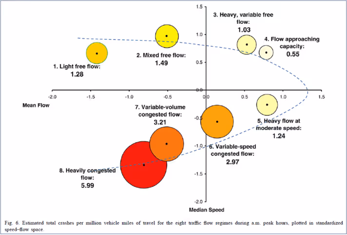
On motorways, with increasing traffic density and recurrent congestion, a shift away from run-off the road crashes towards rear-end crashes was observed over recent years. The increasing share of rear-end crashes can be linked to drivers being caught by surprise when approaching a congestion end (e.g. a ‘shockwave’ moving against the direction of travel) or minor stoppages created by vehicle clusters, called ‘nucleations’ in contemporary traffic flow theory (Kerner 2017). Golob et al. (2004), as well as Hovenden et al. (2020), have clearly shown that for local conditions, the crash risk is linked to the traffic state, i.e. it increases exponentially when transitioning from free flow to congestion (refer to Figure 2 – approximate speed-flow curve was added by the author as a dotted line).
Figure 2: Estimated total crashes per million miles of travel for the eight traffic flow regimes during AM peak hours, plotted in standardised speed-flow space. Source: Golob et al. (2004)
Holistic solution for motorways
Oversaturation causing these phenomena can be largely avoided by employing the following 2 approaches that cover both the planning and operational phases:
proper design based on appropriate relationships between the forecast traffic volume and capacity
if oversaturation is still occurring, it can be partially mitigated through Intelligent Transport Systems (ITS) based measures, such as traffic management combined with dynamic traveller information.
Traffic demand and motorway capacity are dynamic components that result in a certain traffic flow outcome experienced by motorists. If the motorway design does not rigorously account for the relation between these two components, frequent congestion occurrence will be built into the infrastructure (as some Australian examples have recently shown). ITS such as Coordinated Ramp Metering cannot generally correct a bad design. However, these systems are suitable to deal with the short-term ‘spikes’ caused by random or systematic fluctuations. Overall, these two approaches provide a holistic solution to address the oversaturation issues on motorways.
While this article focuses on motorways, with increasing traffic levels, many of the insights and considerations presented here are transferrable to other road types.
The importance of realistic motorway capacity guidance for appropriate design
The process of evaluating and comparing the operational effects of alternative road planning and design scenarios is at the core of different HCMs around the world. It allows analysts to screen a variety of scenarios and select a reasonable one to ensure optimal investment in infrastructure. Central to this process are capacity values for certain road infrastructure specifications (e.g. number of lanes) which, if compared to the forecast traffic demand, allow for a prediction of the expected traffic flow quality (or Level of Service – LOS).
The general principle of proper urban road design is that the carriageway capacity should be greater than or equal to the ‘typical’ demand during peak hours so that frequent oversaturation and, hence, recurrent congestion, will be avoided. ‘Typical’ demand during peak hours can be estimated based on extrapolated traffic counts or on strategic traffic modelling.
It has become increasingly evident that the US HCM (Transportation Research Board (TRB) 2022), which is primarily referenced by Australian practitioners and is also heavily cross referenced in Australian guidelines (i.e. Austroads publications), provides ‘capacity’ values that do not reflect what is sustainably achievable on typical Australian motorways within large metropolitan cities with the following characteristics:
very high traffic demands spread over extended peak periods
closely spaced entry and exit ramps
a dynamic mixture of long trips with a high turnover of relatively short trips.
This implies that there is a risk of insufficient capacity being built into the infrastructure. The occurrence of recurrent congestion and the corresponding negative safety impacts due to inappropriate design must be avoided through more realistic capacity guidance. The risk of flow breakdown at certain traffic levels must be understood and quantified so that planning, design and operational strategies can be used to avoid an unacceptable risk due to congestion while still appropriately utilising these most important pieces of road infrastructure.
Based on this issue, Victoria’s Department of Transport and Planning has developed the first version of its own Motorway Capacity Guide (MCG), as part of the broader Managed Motorway Design Guide (MMDG) (VicRoads 2019), which focuses on motorway carriageway capacity values. Figure 3 shows the relationship between the flow rate (on the x-axis) and the speed (bottom plot, solid blue line); and the flow breakdown risk (top plot, solid red line) and the productivity (top plot, solid blue line). Note that the productivity is the mathematical product of flow and speed.
The optimal design capacity or Maximum Sustainable Flow Rate (MSFR), a new term used to reflect the HCM’s own capacity definition which requires the flow rate to be sustainable, is illustrated by the vertical red dotted line. In this case, the MCG has adopted the flow rate at 1% Flow Breakdown Risk (FBR) per 15-minute interval (or around 10% for a 3-hour peak period) as the Maximum Sustainable Flow Rate (MSFR). This coincides with the highest productivity (refer to Point 3 in Figure 3). This approach is reasonable to ensure good network reliability and productivity that is close to its maximum. In addition, the operation of the ALINEA/HERO based Coordinated Ramp Metering system in Victoria is based on operating the motorway at a 1% FBR per 15-minute interval.
Figure 3: Breakdown probability, productivity and speed plotted against flow rate (4 lane cross-sections)
A recent study by NTRO has investigated and compared various methodologies used by the member states to determining capacity, including those included in Victoria’s DTP MCG (Bennet & Naznin 2020). The study also includes stakeholder consultations across all Australian states and territories. From this comparative analysis study, it was found that all states and territories were agreeable to adopting Victoria’s DTP MSFR methodology into a national guideline.
The role of ITS to manage oversaturation and adverse driving conditions
Oversaturation on motorways cannot be eliminated by design alone. ITS provides the tools to minimise and mitigate the consequences of unavoidable congestion in a safe and controlled manner. It has been proven that Managed Motorways compared to Unmanaged Motorways are around 30% safer (Gaffney et al. 2017). Ramp metering at motorway entries is a good example of how to facilitate unavoidable vehicle storage in a low-speed environment so that mainline flow breakdowns and dangerous situations can be avoided. As another example, Variable Speed Limits (VSL) as an integral part of a Lane Use Management System (LUMS) on the approaches to a congestion end, are suitable for reducing the speed differential between arriving vehicles and those at the tail end of the congestion, which will mitigate the risk of rear-end crashes.
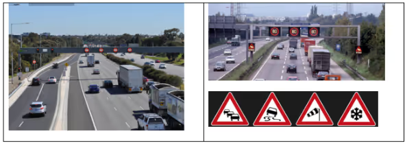
Opportunities exist in the ITS or Smart Infrastructure space to address dynamic traffic and weather conditions. There is already Managed Motorway technology in place in Victoria and other Australian states (including telecommunications, gantries and variable message signs) that can be easily expanded to include dynamic speed reductions, as well as more comprehensive traffic and weather condition warnings (refer to Figure 4).
Figure 4: Managed Motorway technology in Melbourne (left) and Frankfurt am Main, Germany (right), the latter capable of displaying warnings of congestion and adverse weather conditions.
Conclusions and future works
In conclusion, given that good design decisions can reduce the crash risk for multi-million travellers per year, the development of high-quality (i.e. clear, realistic, succinct and user-friendly) capacity guides deserves more attention and should be completed on an Australia and New Zealand level to achieve better road design as a contribution to Vision Zero.
Significant motorway projects are currently underway that require the availability of systematically determined and evidence-based motorway capacity values for Australian metropolitan conditions (surface or tunnel sections). The time to take action to improve the design and operation guidelines for motorways around Australia and New Zealand is now.
Austroads has recently announced that they will seek to undertake a project to update their traffic management guide to provide typical and realistic capacity values for basic motorway/freeway segments for all of Australia and New Zealand. This is an excellent opportunity to scientifically develop a guideline for nationally consistent capacity values.
In parallel, NTRO is in the process of bringing together a team of Australian road operators interested in expanding the developed MCG to include guidance on dealing with capacity reduction due to concentrated lane changing, as is typical for weaving areas. Promising new approaches have recently been produced by US work (Update of Highway Capacity Manual: Merge, Diverge, and Weaving Methodologies (TRB 2023)) and published in a Victoria’s DTP TRB Annual Meeting contribution (Zurlinden et al. 2021).
These 2 initiatives are major milestones towards the vision of having Australian and New Zealand highway capacity guidance for all road types that is realistic for local conditions and is easily applied by practitioners. Additionally, Victoria’s DTP possesses a large number of state-of-the-art in-pavement detectors (TIRTL) capable of permanently measuring lane changing between 2 adjacent cross-sections. To the author’s knowledge, the availability of such data is unique in the world. The existence of such comprehensive data will allow us to combat the shortcomings of US HCM weaving area capacity analysis and place Australia as a world leader in managed motorways.
References
Bennet, P & Naznin, F 2020, Improved traffic management guidance: freeway capacity analysis, report AP-R644-20, Austroads, Sydney, NSW.
Gaffney, J, Lam, P, Somers, A, Johnston, D & Boddington, K 2017, VicRoads managed motorways framework: Appendix A, VicRoads, Kew, VIC.
Golob, TF, Recker, WW & Alvarez, VM 2004, ‘Freeway safety as a function of traffic flow’, Accident Analysis and Prevention, vol. 36, no. 6, pp. 933–946. doi: 10.1016/j.aap.2003.09.006.
Hovenden, E, Zurlinden, H & Gaffney, J 2020, ‘Safety on heavily trafficked urban motorways in relation to traffic state’, Journal of Road Safety, vol. 31, no. 1, pp. 51–65, doi: 10.33492/JRS-D-19-00247.
Kerner, B 2017, Breakdown in traffic networks: Fundamentals of transportation science, Springer, Berlin, Germany.
Transportation Research Boad 2022, USA highway capacity manual – A Guide for Multimodal Mobility Analysis, 7th edn, TRB, Washington, DC.
Transportation Research Boad 2023, Update of highway capacity manual: Merge, diverge, and weaving methodologies, TRB, Washington, DC.
Zurlinden, H, Baruah, A & Gaffney, J 2020, ‘Towards linking driving complexity to crash risk’, Journal of Road Safety, vol. 31, no. 1, pp. 66–80, doi: 10.33492/jrs-d-19-00070.
Zurlinden, H, Hall, M & Gaffney, J 2021, ‘Applying new methods for assessing the impact of weaving and lane changing intensity on motorway capacity’, TRB Annual Meeting, 2021, online/virtual event, TRB, Washington, DC.
Dr Hendrik Zurlinden
Principal Engineer
NTRO
Interiew
Optimised Motorway Design and Operation as a Contribution to Vision Zero