Automation Improvements for the Australian Level-Crossing Assessment Model
To address the current limitations of the ALCAM process, NTRO was engaged in 2022 to lead and deliver a collaborative multi-stage project funded by the Department of Transport and Planning (DTP) Victoria. This project sought to investigate how the ALCAM process could be optimised via the integration of modern technologies.
This article was featured on NTRO on February 16, 2026
To evaluate the safety risks at Australian railway level crossings, the Australian Level Crossing Assessment Model (ALCAM) is employed. Traditionally, ALCAM assessments utilise information obtained through manual inspections undertaken by authorised personnel. As such, the process can be time-consuming, resource-intensive and limited by funding and inspector capacity/availability. This can result in level crossings being inspected inadequately (e.g. once every seven years), limiting the availability of up-to-date data for risk management and informed decision-making.
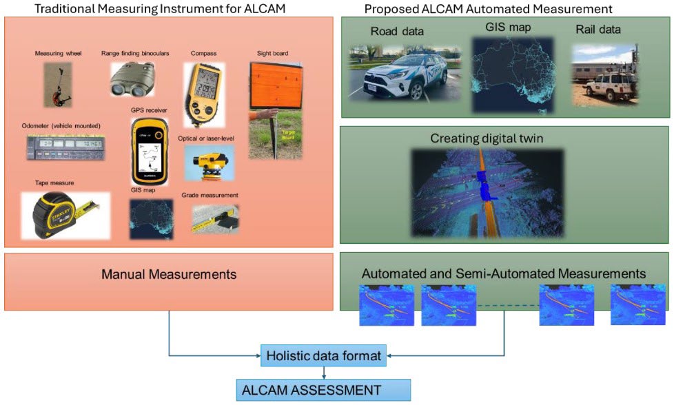
To address the current limitations of the ALCAM process, NTRO was engaged in 2022 to lead and deliver a collaborative multi-stage project funded by the Department of Transport and Planning (DTP) Victoria. This project sought to investigate how the ALCAM process could be optimised via the integration of modern technologies (see Figure 1), including automated data collection, virtual inspection techniques and machine learning. Delivery of this project would reduce resource-dependency and facilitate more frequent delivery of inspection data, making up-to-date and accurate inspection data available to stakeholders to utilise in managing risks and prioritising safety risk at level crossings.
Figure 1: ALCAM Automation concept to streamline sight measurements for ALCAM surveys
2. Project Overview
The work to improve the ALCAM process was scoped as a three-stage process:
Stage 1: a desktop review of current ALCAM practices, highlighting inefficiencies and areas for improvement.
Stage 2: initial integration of technology to assess feasibility, including data collection and proof-of-concept trials for semi-automated inspections.
Stage 3: continuation of the feasibility assessment of integrating technology to reduce manual effort, improve efficiency and uphold safety standards.
2.1 Stage 1
Stage 1 of the project was undertaken in 2022/2023 and focused on a desktop assessment of the current ALCAM approach. The existing ALCAM process was assessed to identify any potential untapped efficiency gains (e.g. optional alternative data sources to mitigate the need for on-site assessment data collection). Applicable technologies were also identified and investigated to understand associated costs and potential for use.
Outcomes of the literature review in this stage revealed the following:
The ALCAM input parameters for each component of the model are gained from an on-site assessment and then inserted into a level crossing management (LXM) portal from which the ALCAM risk score is calculated.
Some parameters are auto-populated based on other manual inputs (either entered by the ALCAM assessor or imported from an appropriate file).
Following the literature review, stakeholder and industry consultation was undertaken to identify and prioritise which ALCAM characteristics and LXM input parameters are time-consuming/difficult to assess on-site and would benefit greatly from automation. Six such characteristics (which correlate to 23 primary LXM input parameters and a further 100 secondary LXM input parameters) were identified as follows:
Sight distance.
Crossing signage/marking.
Size limit/clearance.
Crossing layout.
Vegetation management.
Train situation.
To facilitate automation of calculating the above parameters, technology currently utilised in the rail and road sector was reviewed in consultation with industry experts in data collection also including visualisation, software development and AI model development. The outcomes of this investigation indicated the following technologies (generally in various combinations to allow for calculation of ALCAM characteristics) are most applicable to this project:
Aerial and satellite imagery (including Interferometric Synthetic Aperture Radar).
High-resolution digital cameras mounted to road/rail vehicles.
Light Detection and Radar (LiDAR) units mounted to road/rail vehicles.
Global Navigation Satellite System (GNSS) units required for georeferencing data.
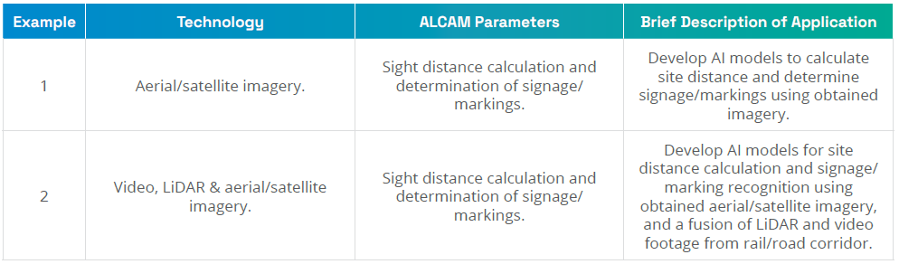
The applicability of these identified technologies, in various combination (examples given in Table 1), were assessed to then determine the viability of undertaking AI model proof-of-concept trials in Stage 2 of the project. This assessment yielded a decision to develop AI models using LiDAR & video data from NTRO’s iScan vehicle to assess sight distance, signage/markings and clearance widths.
Table 1: Examples of technology for proof-of-concept trials
2.2 Stage 2
Stage 2 of the project was undertaken in 2023/2024 with the aim of developing and implementing AI-based models for feasibility assessment to optimise ALCAM processes. This stage of the project involved data collection, manual assessment, virtual assessment and the development and refinement of AI models.
Within this stage, ten Victorian locations, covering a diverse range of control types, mechanisms and traffic layouts, were identified to be surveyed and assessed. These locations were subject to both manual inspection and NTRO iSCAN vehicle (video and LiDAR) data collection methods, to gather information reflective of current industry practice and for the potential automated practices. This information was then supplied to collaborating partners to begin development of AI models for selected ALCAM/LXM parameter inputs. The development of the AI models broadly included:
Processing NTRO’s iSCAN data and comparing this with the manually collected data.
Georeferencing the collected road/rail data points.
Preliminary development of AI models based on selected ALCAM parameters (critical parameters identified as sight distance measurements, signage/marking identification, and clearance width).
Comparison of AI models with manual and virtual assessment outcomes.
Refinement of AI models for feasibility assessment.
In developing these models, a couple of challenging aspects were identified and addressed to ensure quality and accuracy of the resultant models and their outputs. These challenges were most notably:
Ensuring the quality and accuracy of collected data for training the AI models.
Addressing potential inaccuracy in the data collection and model development processes.
At the end of Stage 2, the process for developing a digital twin framework for the ALCAM process was refined by evaluating the feasibility of automation through assessing the developed AI models and identifying attributes that require more detailed analysis. Continued refinement of these models was undertaken in Stage 3.
2.3 Stage 3
To improve consistency, efficiency and safety in support of reducing incidents at level crossings, Stage 3 of the project (2024/2025) undertook testing of integrating the digital twin model, as well as formulating a roadmap towards full automation of the field survey process. The focus on full automation in this stage of the project set out to:
Assess the feasibility of automated system development for field data collection to integrate with existing ALCAM processes.
Test and validate an automated system at various level crossings across Victoria.
Propose methods for completing the system design, alongside recommendations for its application across the national rail network.
Demonstrate clear benefits to stakeholders (e.g. faster data collection, reduced costs and decreased manual surveying by which improved worker safety is achieved).
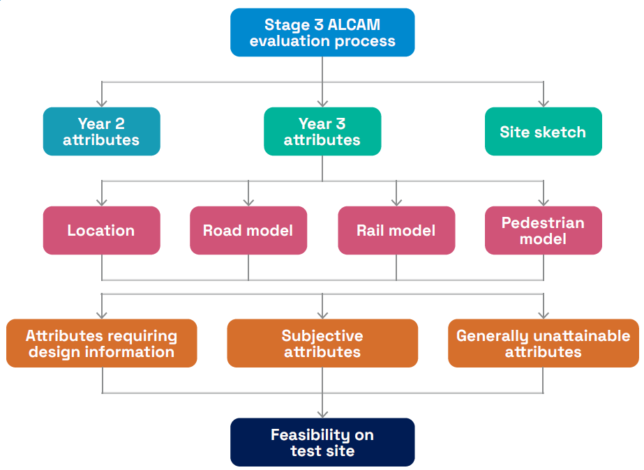
This continued investigation into the feasibility of modernising and automating the assessment process for railway level crossings in Australia assessed the practicality, effectiveness and efficiency of the proposed solutions/interventions using a structured methodology as outlined in Figure 2.
Figure 2: Stage 3 ALCAM Methodology Flow Chart
The ALCAM evaluation in Stage 3 focused on refining the automation feasibility of attributes identified in earlier phases, as well as broader attribute categories applicable across different models. It considered attributes requiring design data, subjective interpretation or those currently unattainable due to data gaps. Feasibility testing at selected sites assessed the practicality of automating data collection, particularly for challenging attributes, using a mix of field studies, simulations and stakeholder input. Both qualitative and quantitative methods were applied to identify risks, limitations and improvement opportunities. Each attribute was evaluated across road and pedestrian level-crossing models, for their relevance, data needs and automation potential to streamline future ALCAM assessments. A total of 222 attributes were reviewed and categorised as follows:
Inputs and outputs of the road and pedestrian models:
Road model: proximity to intersections, number of lanes, road surface conditions, visibility, signage and sun glare.
Pedestrian model: proximity to stations, schools, event venues, and condition and safety of pedestrian pathways, signage and visibility.
Automation feasibility (focused on attributes that can be collected systematically or inferred from existing data sources, reducing the need for manual data entry):
Data sources: digital maps, LiDAR and imagery used to extract attributes such as proximity to intersections, visibility and signage.
Subjectivity and attainability: some attributes require manual intervention or review due to a lack of data, which are noted for future consideration.
Extended list for automation feasibility:
Specific attributes, such as road level-crossing model inputs (e.g., proximity to stations, visibility of traffic control) and pedestrian crossing model inputs (e.g. pathway gradients, lighting and signage) were prioritised for feasibility testing.
Attributes requiring historical data:
Examples of these type of attributes are heavy vehicle proportion, maintenance effectiveness, train patterns and traffic volumes, which require sources such as digital map information and crowdsourced data, e.g. the traffic layer of digital maps.
Over the course of Stage 3, the methodologies applied to achieve meaningful outcomes from the feasibility testing covered the following steps:
Raw data processing: collecting, aligning and preparing raw data (including aerial maps, rail data and vehicle data) for processing (e.g. georeferencing and point cloud stitching) and analysis.
Development of automation modules: analytical modules to achieve automation of traditionally manual tasks to identify, quantify and categorise conditions and constraints related to level crossings, pedestrian walkways, and visibility and clearance parameters. These modules included precision mapping through laser scanning and triangulation, asset and defect detection via computer vision, and level crossing traffic performance assessments through proposed integration of crowd-sourced data.
Measurement of qualitative attributes: Translating subjective qualities into measurable data via clear criteria and rating systems.
Decentralisation of ALCAM attribute measurement: Proposal of a standardised/holistic data structure and methodology to enable ALCAM task distribution among vendors based on expertise in various ALCAM attributes.
By the end of stage 3, the key findings were noted as follows:
Automation feasibility:
The study demonstrated the potential of automated tools, including laser scanning and AI-driven analysis, to accurately measure many ALCAM attributes.
A semi-automated approach, blending manual expertise with technological innovations, is recommended for the short term due to challenges in automating subjective assessments.
Challenges:
Attributes requiring subjective interpretation or historical design data remain complex to automate.
Variations in automated reporting across vendors highlight the need for standardisation and accreditation processes.
Data standardisation:
The adoption of a holistic data format has been pivotal in ensuring compatibility, efficiency and scalability across multiple vendors and technologies.
Efficiency and scalability:
Automation and structured data formats enabled faster assessments, with a significant reduction in the need for manual field surveys.
3. Next Steps
Overall, this project represents a major advancement in automating and modernising ALCAM, demonstrating through feasibility testing that technologies such as LiDAR, computer vision and digital twins can significantly enhance safety assessments at level crossings. However, further work can be done to continue advancing ALCAM automation, such as:
Accelerated development of semi-automated models: broaden the use of semi-automated tools to handle subjective attributes, with a gradual shift toward full automation where viable.
Standardisation of data collection protocols: invest in consistent data formats to ensure interoperability across technologies and vendors.
Focus on a technology-agnostic solution: design systems that can integrate emerging tools such as AI and crowdsourced data without being bound to specific platforms, ensuring long-term adaptability.
In addition to these recommendations, the project also establishes a foundation for an Accelerated and Automated ALCAM (A-ALCAM) model, where the term "acceleration" refers to approaches that enhance the accessibility and availability of ALCAM surveys, including the use of semi-automated and automated methods leveraging digital twin technology, machine learning and AI systems. As such, the project presents a strong case for future development focusing on:
Testing and validating scalability of semi-automated tools across more sites.
Methods to quantify and integrate subjective and qualitative attributes into automated assessments.
Establishing automated system accreditation frameworks to ensure accuracy and regulatory compliance.